Title

Administrative and Institutional Records 1901 - 1924

Description

Records created by the Office of the President and Office of the Director between 1901 and 1924 relating to university operations, administration, promotion, international relations, and development, including campus life and commencement. Records include correspondence, meeting minutes, speeches, publications, audio/visual materials, and objects. Includes the papers of Director Leroy Anderson (1902-1907), Director Leroy Burns Smith (1908-1914), Robert Weir Ryder (1914-1921), and Nicholas Ricciardi (1921-1924).
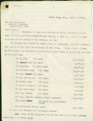
Collection

Displaying results 1 - 3 of 3
Results per page
10
25
50
Local Identifier
0005_ua_000003
Date Created
1902-03-09
Description

Handwritten agreement by Dawson Lowe to sell the property known as the westerly portion of the Phil Ready Ranch and about forty acres along the north portion of the southwest quarter of section twenty-three. Lowe also agreed to give the state a right of way through his lands to the city of San Luis Obispo (what becomes California Street). The Board of Trustees eventually purchases 281 acres from Dawson Lowe.

Local Identifier
0005_ua_000001
Date Created
1902-03-12
Description

Correspondence from California Polytechnic School Trustee F. A. Hihn to California Governor H. T. Gage. Hihn visited San Luis Obispo several times in early 1902 to meet with landowners in the city to decide on the property to purchase for the new California Polytechnic School. Proposals came from well-known San Luis Obispo names such as Goldtree Brothers, Orcutt, Crittenden, Vachell, Venable, and Maree. Ultimately they selected a site owned by Dawson Lowe on the outskirts of town. This letter describes the properties under consideration and some of the reasons why they selected the Lowe property. There is a hand-drawn map in the University Archives which may be the map that Hihn mentions in this letter.

7 items in Collection
Local Identifier
0005_ua_000002
Date Created
1902
Description

Hand-drawn map of Dawson Lowe C. H. Johnson and Dr. Hays properties in San Luis Obispo. Visible is a line representing the Southern Pacific Railroad. Notations for Brizzolara Creek and the hills behind Cal Poly are included. Cal Poly's first 281 acres of land were purchased from Dawson Lowe. The school later purchases the C. H. Johnson property. This map was most likely created in 1902 when the trustees of the school were considering which land to purchase for the new school.

2 items in Collection